 Overall introduction
Combine abilities of cloud computing, big data, AI and Gaode Map, create an intelligent transport solution, empower the traditional transport industry, build intelligent transport brains and enhance the urban transport governance and planning levels. Integrate over 100 types of data, solve the “data silo” and “information silo” problems, complete the whole-process data governance, build a transport algorithm library and achieve the virtuous accumulation of the transport center. Build an intelligent transport commanding center integrating five major functions: information guiding, professional scheduling, standardized operation, whole-process supervision and extensive publicity.

Intelligent transport has become an important breakthrough for the intelligent city construction. At present, viewing from the application maturity angle, video monitoring has completed the most mature and most complete semantic and structured image and video data processing. No matter whether it is used as an intelligent video monitoring system for vehicles engaged in road transport or electronic police, it is a field with the deepest application. Intelligent transport has been a technological field in which it is the first to solve the data application bottleneck in the current emerging technology and application field.
1.Integrate multi-source data, perceive the full-range transport operation state and find change of the transport operation state in real time.
2.Exchange data for police effort: The qualitative commanding and scheduling has been turned into the quantitative commanding and scheduling and the passive police investigation has been changed into the active police investigation.
3.Support for multiple practical business scenarios: transport jam remission, transport order maintenance, major event guarantee, etc.
4.City Brains of Hangzhou, Shanghai, etc. — Intelligent Transport Service has been quickly implemented and low-cost quick results have been achieved.
01
Non-uniform industrial standards
Due to unbalanced economic development in different regions of China, there were no uniform industrial standards in China when intelligent transport system projects were implemented. Therefore, the intelligent transport systems of many regions are now relatively independent and the connection and cooperation between the systems are weak.
03
Quality of data source
The modernized transport route guidance and transport signal control need real-time accurate transport flow data because the data can be used to judge some transport state and predict some future short-time transport state. However, because the system robustness is not high enough at present, it is difficult to judge the data quality.
02
Stability and reliability of the intelligent transport system infrastructure
With the constant expansion of the system scale and the quick increase of the number of the front end device point positions, the increase of the number of the device fault points is an exponential growth.
04
Information security
The enormous amount of transport data includes some personal sensitive information. The centralized storage of these data increases the sensitive information leak risk.

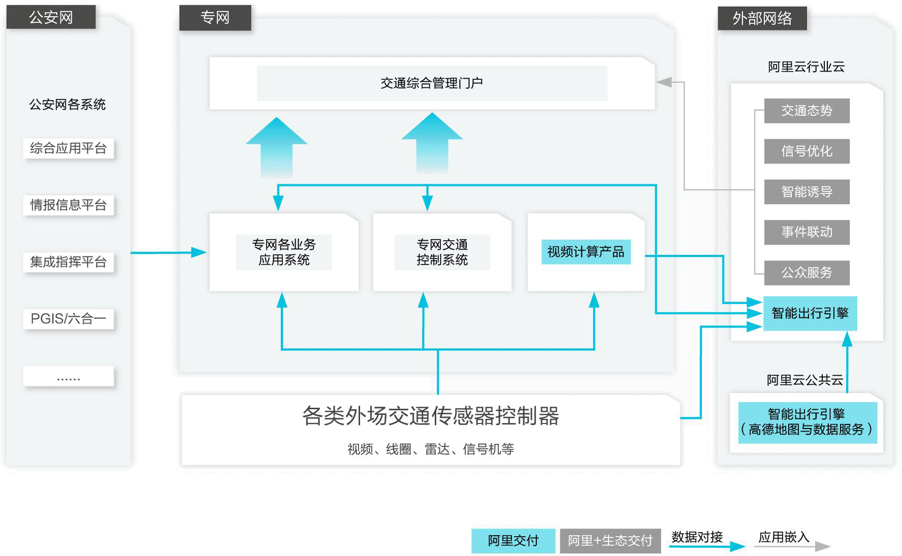
By adopting the mixed cloud architecture, ensure the data security while ensuring the data transmission performance through a dedicated traffic police video network and the transport industry cloud.
Architecture characteristics
1)Light weight: Use the public cloud resources and it is not necessary to carry out the local heavy asset construction.
2)High security: A special line is used to interconnect and ensure data stability and security.
3)High experience: SAAS+DAAS provides multi-scenario intelligent application and data services
 Gaode internet data
Provide abundant Gaode internet data, including road condition data (vehicle speed, travel time, etc.), origin-destination (OD) data and internet incident data. In a medium city, over 100,000,000 groups of data are sent every day. Combine the data with the traffic police side data, analyze the data, and provide more comprehensive and more accurate transport parameters and indexes.
 Unified road network centers
Based on the unified multi-source data integration, considering from the transport angle, build a road network structure applicable to big data analysis scenarios, and code all the standard definition and high definition maps in a unified way. Connect and manage facilities and devices of unified expression networks, and analyze and mine historical data in real time.
 AI visual intelligence
The large-scale real-time AI visual intelligence capability has integrated the world-leading AI visual intelligence technology. It is usually very compatible with the external devices. It can accurately calculate the incoming video stream on a large scale in real time, and identify various transport parameters and dozens of types of transport incidents.
 Multi-dimensional intelligent models
Provide multi-dimensional intelligent models for different transport application scenarios, including multi-scenario signal timing optimization (isolated intersections, road sections, subareas, etc.), transport organization optimization, real-time important vehicle supervision and intelligent guidance.